


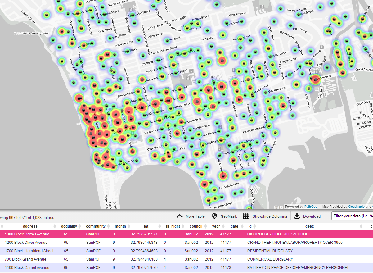
“HDMA GeoViewer” for Nepal Earthquake Disaster Response and AssistanceSMART DashboardGeoViewerHDMA Education Resource
Bring Both Distinction and Distinctiveness to SDSUSan Diego State University has strong existing research groups in both spatial science and social behavioral research (including transnational migration and immigrant community study, social and physical environmental influences on health and health behaviors relevant to obesity, diabetes, and other health risks, and urban ecosystem design with livable streets, pedestrian and bicycle transportation programs, social media and mapping cyberspace etc.). By integrating sound theory-based frameworks with mobile data collection tools (from smart phones with GPS, cameras and voice recorders) and spatial analysis capabilities, HDMA cluster initiative can transform SDSU faculty research activities into a higher level of understanding and explanations of human dynamics.
Fall 2014 and Future Tasks
|
SDSU Research Showcases1. September 2, 2014: Dr. Ming-Hsiang Tsou (Director) received the NSF-IBSS (Interdisciplinary Behavioral and Social Science Research) Award. The project entitled: "IBSS: Spatiotemporal Modeling of Human Dynamics Across Social Media and Social Networks."(http://socialmedia.sdsu.edu/) This is a four-year award (2014-2018) for $999,887. One key contribution of this project is to build a prototype for the San Diego Office of Emergency Services (OES) social media outreach platform, which may be applicable for other U.S. cities in the future. The design of the prototype is to facilitate rapid dissemination of official alerts and warnings notifications from OES during disaster events via multiple social media channels to targeted population (typically in certain area). The platform can identify and recruit top 1000 social media volunteers based on their social network influence factors and help government agencies communicate more effectively to the public and be better prepared for both natural disasters and human-made crises. 2. 2010-2014. National Science Foundation: “CDI-Type II: Mapping Cyberspace to Realspace: Visualizing and Understanding the Spatiotemporal Dynamics of Global Diffusion of Ideas and the Semantic Web. Award # 1028177. $1,300,213. Ming-Hsiang Tsou (PI, Geography SDSU), Co-PIs: Dipak K Gupta (Political Science, SDSU), Jean Marc Gawron (Linguistics, SDSU); Brian Spitzberg (Communication, SDSU), Senior Personnel: An Li (Geography). (http://mappingideas.sdsu.edu/) This NSF-CDI project integrates GIS, computational linguistics, web search engines, and social media API to track and analyze public-accessible websites and tweets for visualizing and analyzing information landscapes of ideas in cyberspace. 3. IBACH (The Institute for Behavioral and Community Health) investigators currently have approximately $10 million per year in funding from NIH, the CDC, -and other funding agencies, with many of our projects including important spatial science and GIS elements. Dr. John Elder is the Director of IBACH. New initiatives by our core investigators Elva Arredondo, Suchi Ayala, Linda Gallo, and others will depend on GIS and mobile technology. IBACH's CDC-funded multi-site intervention trial to prevent and control childhood obesity in Imperial County (led by Suchi Ayala) includes a spatial component. The multi-site Hispanic Community Health Study/Study of Latinos (led by Greg Talavera at the San Diego site) prospective cohort study of 16,000 individuals of Latino descent would provide an excellent opportunity to pursue questions regarding social and physical environmental influences on health and health behaviors, in an at-risk and understudied population. 4. Dr. Sheldon Zhang is currently Co-Principal Investigator of a study funded by the National Science Foundation that examines the spatial and structural processes of social order maintenance in Tianjin, China (a municipality with about 13 million residents). A stratified multistage sampling is currently being carried to obtain a sample of 2,500 residents from 50 neighborhoods across the city to explore how crime and social-disorderly activities are distributed, perceived, and managed. The study seeks to understand the structural and interstitial relationships among different social control agents, e.g., police, neighborhood committees (a form grass-root government agency), private security companies, homeowner associations, and private citizens. 5. 2007-2013. National Institute of Child Health and Human Development: Health, Poverty and Place: Modeling Inequalities in Accra Using Remote Sensing and GIS, $2,500,000 , John Weeks (PI, Geography SDSU). Co-PI - Allan Hill (Public Health, Harvard), Co-PI - Arthur Getis (Geography SDSU), Co-PI - Douglas A. Stow (Geography SDSU), Collaborator: Stephanie Brodine (Public Health, SDSU). 6. 2011-2014. National Academy of Science’s Transit Cooperative Research Program (NAS/TCRP project H-45: Livable Transit Corridors: Methods, Metrics and Strategies, $400,000.) Dr. Bruce Appleyard (Public Affairs) is helping lead a nation-wide geo-spatial analysis of transit corridors, examining social, economic, and environmental opportunities and outcomes resulting from various policy and design decisions. This work includes analysis of station area planning, transit service and market segment analysis, and the emerging field of sustainability/accessibility planning. Bruce is also helping guide various planning and policy and design decision through the development of GIS-based decision support tools and frameworks. |
 Advances
in geography, sociology, political science, anthropology, economics, public affairs,
public health and other health sciences, ecology, and communication have been made
through the application of spatial analysis and advanced spatial technologies, including
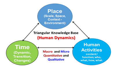
GIS, GPS, remote sensing, and spatial statistics. New insight into the dynamics
of social systems can not only help to verify the existing social behavioral theories
but also contribute to problem solving in the range of areas vital for today’s society
from crime prevention, through transnational migration, to spread of infectious
diseases.
Advances
in geography, sociology, political science, anthropology, economics, public affairs,
public health and other health sciences, ecology, and communication have been made
through the application of spatial analysis and advanced spatial technologies, including
GIS, GPS, remote sensing, and spatial statistics. New insight into the dynamics
of social systems can not only help to verify the existing social behavioral theories
but also contribute to problem solving in the range of areas vital for today’s society
from crime prevention, through transnational migration, to spread of infectious
diseases.
 By
collaborating with mobile technology and GIS industry, faculty research projects
can utilize the most advanced mobile data collection technologies, high speed wireless
networks, and advanced spatial analysis functions, to collect and analyze real-time
survey and feedbacks from individuals (via mobile apps, online survey, social media,
medical sensors, etc.). A large number of social and human behavior datasets can
be easily collected using mobile technology. Spatial and behavior science can provide
an effective and efficient way to visualize and analyze these big data collected
for social behavior research activities. In addition, with the signing of California’s
Senate Bill 375, the Sustainable Communities and Climate Protection Act of 2008,
GIS- based scenario planning and decision support for regional land-use and transportation
plans are, for all practical purposes, now mandated statewide. We propose to establish
a collaborative, inter-disciplinary Human Dynamics and Decision Support Center,
which will conduct research on human dynamics in mobile age and become a major think
tank to local, regional, and federal government agencies for the policy making and
policy implementation in public affair. This new research center will collaborate
with other SDSU faculty in other colleges (Engineering and Business) in the areas
of mobile applications, wireless geolocation technology, and marketing analysis
with social media, etc.
By
collaborating with mobile technology and GIS industry, faculty research projects
can utilize the most advanced mobile data collection technologies, high speed wireless
networks, and advanced spatial analysis functions, to collect and analyze real-time
survey and feedbacks from individuals (via mobile apps, online survey, social media,
medical sensors, etc.). A large number of social and human behavior datasets can
be easily collected using mobile technology. Spatial and behavior science can provide
an effective and efficient way to visualize and analyze these big data collected
for social behavior research activities. In addition, with the signing of California’s
Senate Bill 375, the Sustainable Communities and Climate Protection Act of 2008,
GIS- based scenario planning and decision support for regional land-use and transportation
plans are, for all practical purposes, now mandated statewide. We propose to establish
a collaborative, inter-disciplinary Human Dynamics and Decision Support Center,
which will conduct research on human dynamics in mobile age and become a major think
tank to local, regional, and federal government agencies for the policy making and
policy implementation in public affair. This new research center will collaborate
with other SDSU faculty in other colleges (Engineering and Business) in the areas
of mobile applications, wireless geolocation technology, and marketing analysis
with social media, etc.